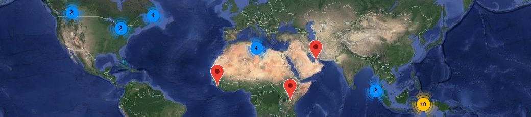
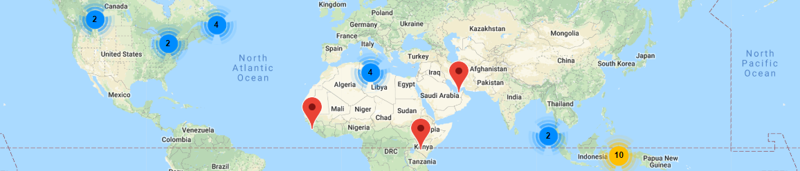
|
Web GIS and Database Specialist with the Northwest Territories Geological Survey (NTGS).
Sector(s)/Subsector(s): Geoscience Information Management
Project Goals/Overview
- Redesign and redeployment of all web-based geosciences information services for the Northwest Territories Geological Survey(NTGS), NT, Canada.;
- Manage the inputs/outputs of user groups and development consultants;
- Challenging factors included budget and human resource constraints.
Achievements:
- on-boarding of senior management;
- selection of an architecture and development framework that was manageable and compatible with local agencies;
- careful selection of external consultants;
- spirited teamwork, and importantly;
- consistent, meaningful collaboration with NTGS partners.
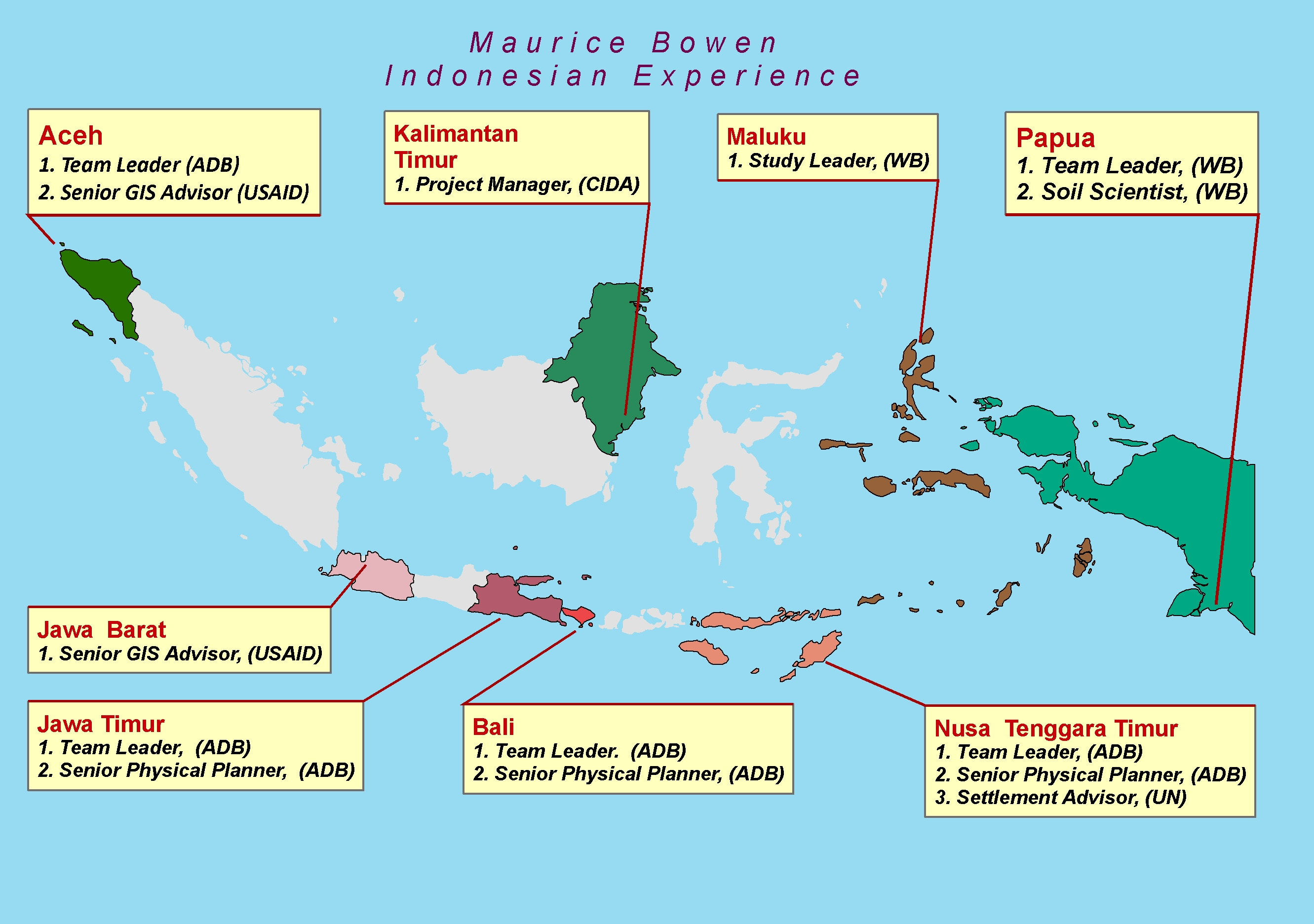
Team Leader/GIS Specialist with ADB to advise the Government of ACEH, Indonesia on the
establishment of a Forestry Information Management System (FIS).
Sector(s)/Subsector(s): Forestry and Environment / Watershed - Based Forestry Management
Project Goals/Overview
- To provide Information Support for sustainable management of the world's largest remaining tropical forests in
Sumatra thereby maximizing economic, social and environmental benefits;
- Delivery of a Capacity Building and Institutional Strenghtening Program for enhanced operational forest
management and;
- Challenging factors included a post-tsunami operational environment as well as competing stakeholder interests
arising from governance autonomy, a logging moratorium as well as a growing interest in the carbon-trading
market.
Achievements:
- Design, installation and testing of a state of the art Forestry Information System (FIS);
- Facilitation and coordination of the work of 7 international and 20 National experts in Forestry, Environment,
and Land Resource Science, Land Use, and provision of technical support to GIS, RS teams;
- Strategic planning and client/stakeholder liaison/consultations;
- Delivery of a Capacity Building Program Institutional Strenghtening Program which included detailed 12 User
Guides for the installed FIS, and;
- Preparation of Final Reports and Maps.
Soil Information System Team Leader and GIS Administrator, UAE with ADB to advise the
Government of Libya on the establishment of a Forestry Information Management System (FIS).
Sector(s)/Subsector(s): Environment and Agriculture / Spatial Planning & Decision Support for Natural
Resource Management
Project Goals/Overview
- The Environmental Agency of Abu Dhabi required the development of an Abu Dhabi Soil Information System (ADSIS)
to support the management of its soil and land resources;
- The development model required a Software Development Life Cycle (SDLC) approach compliant with international
and national systems architecture standards, and;
- ArcGIS Server was chosen as the applications platform with a SQL backend database.
Achievements:
- Design of ADSIS Software Development Plan and implementation of subsystems such as an ArcGIS Server based online
web mapping system;
- Delivery of 12 software development reports, including user documentation/online help system, and;
- Management of the development team and associated subcontracts.
Senior GIS Advisor, supporting USAID's Program to Support for Peaceful Democratization (SPD)
Indonesia.
Sector(s)/Subsector(s): Governance and Community Based Development / Information Support for Management of
Grants to Civil Service Organizations (CSOs).
Project Goals/Overview
- Many Indonesian communities in Sumatra are transitional from disaster and conflict to democratic governance.
- USAID's Support for Peace and Democratization (SPD) Programme supports this transition by providing capacity
building and grants to Civil Society Organizations (CSOs);
- Project implementation and monitoring components require the collection of a large amount of information which
must be analyzed and reported in a manner
that is logically and qualitatively consistent with DAI's and USAID's internal controls and Management
Information Systems (MIS).
Achievements:
- Responsible for oversight in the design, quality assurance and production of databases,
maps, reports and statistical analysis associated with USAID's CSO community grants;
- Served as trainer/mentor for the GIS and Data Management Unit, and;
- Managed quality control of Outputs Quality Assurance db, Village Profiles database, Community Action Plans
database, and a number of databases from subcontractors.
Chief Technical Advisor/Information Specialist with UN-FAO to advise the Government of
Libya on the establishment of an Integrated Land Resource Information Management System.
Sector(s)/Subsector(s): Agriculture and Environment / Information Management for Natural Resource Management
Project Goals/Overview
- Information Management for Natural Resources and Planning:
- The Government of Libya in the late 1990's, recognizing that Land Degradation was an issue facing agricultural,
environmental and economic development decided to consolidate all its land-based information as an Integrated
Land Resource Information Management System (LRIMS).
- Project components included data sourcing from a number of Land Resouces agencies, formation of Land Resources and
Spatial Data Management workgroups, and the design and implementation of an Integrated Land Resource Information
Management System (LRIMS), and;
- Subcontract design and supervision for the procurement of rangeland information subcontracts by remote sensing.
Achievements:
- Establishment of national training program for Geographic Information Systems (GIS);
- Formation of National Working Groups in Agriculture (Soil and Land Use), Geodetic Survey, Remote Sensing (RS),
GIS, and Environment (Meteorology, and Water Resources);
- Preparation of Terms of Reference (TOR) and selection of international consultants for inputs to develop
computerized applications for land evaluation, planning and management at national and regional levels;
- Successfully managed the signing of Letters of Agreement (LOAs) between the United Nations (FAO) and two
National Remote Sensing Agencies, and;
- Worked closely and cooperatively within the Ministry of Agriculture Officials.
Regional Team Leader/Senior Physical Planner for an Asian Development Bank (ADB) Land
Resource Evaluation and Planning Project (LREP II/D), Denpasar, Bali. Indonesia.
Sector(s)/Subsector(s): Physical Planning / Information Management for Natural Resource Management
Project Goals/Overview
- The Second Land Resource Evaluation and Planning Project (LREP2) was intended to increase institutional
capacity in three key government mapping agencies;
- There were four executing agencies (EAs): (i) the National Coordinating Agency for
Surveys and Mapping (Bakosurtanal) for the GLRIS; (ii) the National Land Agency (BPN) for
land use mapping; (iii) the Center for Soil and Agroclimate Research (CSAR) within the Ministry
of Agriculture for soil resource mapping; and (iv) the Directorate General of Regional
Development (DGRD) within the Ministry of Home Affairs for the physical planning component;
- LREP II/D, the Spatial Planning Component, was executed by DGRD and aimed to improve physical planning
processes in the provincial planning agencies (BAPPEDAs);
- The entry points for the LREP II/D Component was in the areas of land zoning and policy option maps using GIS
technology, and;
- Capacity Building in spatial planning was an important activity under this component.
Achievements:
- As Regional Team Leader, represented the ADBs National level project for 5 provinces of East Java, Bali, Nusa
Tenggara Timor, Nusa Tenggara Barat, and Timor Timor (former East Timor);
- Managed the regional project office including oversight all administrative, financial and human resources
and logistical activities;
- Developed and implemented a GIS-based decision support system using development planning models;
- The planning models accessed and derived land resource information to support rule-base planning from about 25
national and international sources, including, FAO land evaluation criteria, USDA soil mechanical criteria for
buildings, erodability, including volcanic eruption, landslides and environmental contamination from
agriculture, municipal and industrial sources;
- Effectively demonstrated the development planning models in 20 Pilot Project Areas involving a wide range of
policy options for Agriculture, Fisheries, Forestry, Municipal Planning, Mining and Tourism sectors, and;
- Implemented Capacity Building activities for Planning Officials in the provincial BAPPEDAs;
An Additional 6 years work in Canada in these roles:
MAURICE BOWEN: CURRICULUM VITAE
|
|
|
|
CONTACT INFORMATION |
Address
Yellowknife, Northwest Territories
Canada
X1A1L2
Telephone
(Canada): Cell Phone (1) 647 381 6538
E-mail: mauricebowen@hotmail.com
|
EDUCATION & TRAINING |
B.Sc. (Agr.), Honors Soil Science, 1980, University of Guelph, Ontario Canada
Honors Thesis Dissertation: The role of Freezing and Water Table Management in the Subsidence of
Cultivated organic Soils [Wetlands].
B.S. /B.Ed. 1969-1974 Memorial University, St. John's, Nfld. 40 of 50 required courses completed,
including all core Biology/Ecology.
Examples of University Credits: 13 biology, 10 land resource sciences, economics, statistics, computer
science, geology, chemistry, engineering, education, scientific writing, pesticides in the environment,
meteorology, remote sensing, applied aquatic biology.
Additional Training: Cartography, surveying, CAD, GIS theory, geodesy; geo-referencing, spatial data
transformations, raster & vector file formats and file conversions, owner & operator of a data capture
service for AM/FM, GIS and CAD clients.
|
PUBLICATIONS |
1982 Report: Detailed Soil Survey of Kings County, Nova Scotia.
1984 Final Report: Detailed Soil Survey of Kings County, Nova Scotia.
|
VOLUNTEERING: |
Past President, (3 years) Newfoundland & Labrador Peat Association
Sponsor & organizer,"Newfoundland & Labrador Peat Opportunities: An International Conference, 1993, Nfld.,
Canada."
|
REFERENCES |
Available on request.
|
PROFESSIONAL WORK EXPERIENCE |
| 1. PROJECT: |
SOUTH ASIA SUBREGIONAL ECONOMIC COOPERATION INTEGRATED TRADE FACILITATION
PROGRAM -RECRUITMENT OF CONSULTANTS FOR THE SASEC INTEGRATED TRADE FACILITATION PROGRAM (53260-002) (DAKAH), BANGLADESH.
Project Description
ADB Project: The Program will help improve Bangladesh’s border infrastructure and trade
facilitation environment, thereby contributing to the national goals of promoting a
favorable industrialization and trade policy regime. The Program will support Bangladesh’s
implementation of the World Trade Organization's (WTO’s) Trade Facilitation Agreement
(TFA), and related best practices on transport and trade facilitation. This project is
being implemented under a work-from-home arrangement due to pandemic-related restrictions.
|
| Location & Dates: |
Remote Work Canada) |
| Position: |
"SENIOR INTERNATIONAL IT/GIS EXPERT":
Currently implemented as a work-from-home due to pandemic restrictions. As the Senior IT
Expert, I advise a Team of 40 experts on the available technologies and costs of
institutional strengthening for cross-border road and rail shipments; recently submitted
the Project Inception Report.
Tasks/Achievements:
As the lead IT Expert, my inputs involve:
- advising a Team of 40 International and National experts on the available technologies,
including ASYCUDA, a computerized customs management system developed by the United Nations
Conference on Trade and Development (UNCTAD) Nations;
- Sourced all spatial data (over 40 map layers of administrative, communication, climate
change/environmental, infrastructure, transportation);
- created Report-ready Maps for 18 Border and Immigration Control Points using open-source
QGIS;
- costs of institutional strengthening for cross-border road and rail shipments.
- wrote all relevant sections for the IT Project Inception and Interim Reports
|
| 2. PROJECT: |
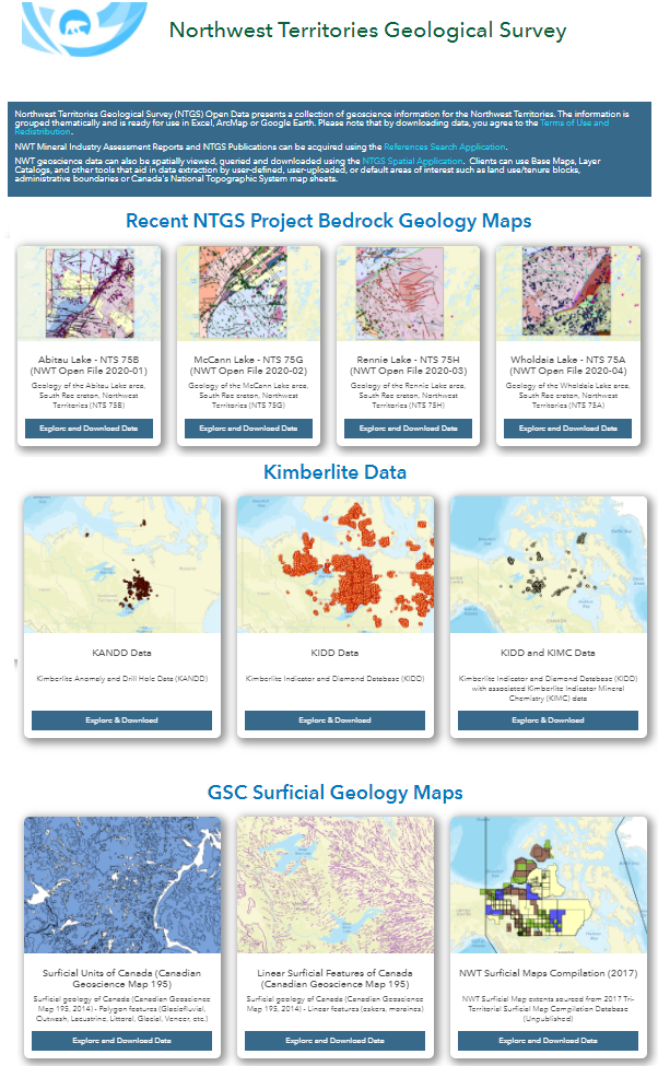
REDESIGN AND REDEPLOYMENT OF ALL WEB-BASED GEOSCIENCES INFORMATION SERVICES
FOR THE NORTHWEST TERRITORIES (NT), CANADA. The Geosciences Office of the Northwest Territories (NTGO),
supported by the Department of Aboriginal Affairs and Northern Development Canada (AANDC) and Government of the
Northwest Territories (GNWT), provides expertise on the mineral and petroleum resources of the NWT. It also
carries out mineral and energy potential studies and non-renewable resource assessments in support of land use
planning, land claim processes, and conservation initiatives. NTGO also compiles, manages and makes available a
variety of geoscientific data, and provides public education and outreach services. It also advises on policy
and programming through the Mining Records Office.
In 2013 the NTGO sought assistance to develop a modern and efficient web-based system for the discovery and
delivery of Geosciences Information Services through a redesign project. Due to the remote location, access
costs and relatively high potential for commercial oil, gas and mineral assets, including gold and diamonds, the
facility needed to respond to a wide client base representing industry, government, academia and the general
public. A System Development Life Cycle (SDLC) approach is employed to identify appropriate and cost-effective
re-design options. Currently technology being deployed includes a LAMPS stack for a customized DRUPAL CMS for
static web pages. Spatial and Tabular Web applications will be supported with GeoCortex, ArcGIS Server, MsSQL
and Visual Studio Web Apps.
|
| Location & Dates: |
YellowKnife, Northwest Territories (NT), Canada (09/2013 TO Present) |
| Position: |
WEB GIS AND DATABASE SPECIALIST:
General
- Overall responsibility for supervising development or modification of systems
, standards, specifications, and
methodologies to address those issues. Analysis of complex scientific/geospatial database access,
management
and
utilization issues, and recommending. Develops and maintains the NTGO website. Specific Task are
summarized
below.
Management & Oversight
- Manages multi-disciplinary teams involved in the development of web-based information systems.
Identifies resource requirements; establishing objectives and goals; developing work plans, priorities,
and
schedules; planning and assigning tasks; motivating personnel; monitoring work performance against
planned
deliverables; resolving conflicts between team members and with contractors and clients.
- Manages relationships with external suppliers, contractors, external end users, and
Management/Information
Technology (IM/IT)
- Oversees financial requirements for special projects; manages and accounts for a budget to provide the
cost-effectiveness and efficiency of external end user services provided; and prepares or reviews
cost-benefit analyses to determine optimum cost.
Research, Analysis, Modeling and Development of Geospatial Solutions
- Analyzes and clarifies the technical parameters of work required for GIS, web mapping and web
programming
projects and services; consults records and reference material; provides technical advice and support
for
project planning activities; and identifies potential technical issues and develops and implements
recommendations.
- Develops, maintains, and delivers data management and web based information services, and performs
research
and development for the NTGO's web enabled databases and GIS systems, which promote discovery and aid
delivery
of NTGO's information stores. Identifies needs related to information management and dissemination, and
creates
and modifies applications to address those needs. Develops and designs custom computer programs for the
World
Wide Web 0NWW) and manages content of the NTGO website.
- Designs, plans and implements GIS, web mapping and web programming projects, through the collection of
appropriate information, data modeling, analysis and programming, for the production of mapping
applications,
maps or data analysis; performs needs analysis, risk assessment and cost/benefit analysis, consults and
provides
expert direction and guidance on GIS, web mapping and web programming applications, activities and
proposals.
- Participates in research projects using GIS technology, by setting up appropriate data
collection/collation
techniques, by analysis or data modeling, by programming of specialized or keystone systems and
applications to
meet operational requirements, and by template and/or digital map production.
- Conceptualizes and manages the conduct of studies and research, and develops proposals for input to such
initiatives as the national framework, national strategic and operational and business development
plans, the
development of internal client and external end user-specific national servicing strategies, innovative
business
approaches, and the planning and implementation of internal client and external end user programs or
projects.
As a subject matter expert, provides functional expertise, leadership and guidance through developing
solutions to address operational problems; developing policies, standards, performance criteria,
implementation
models, optimal approaches and best practices; and developing and delivering training programs to
promote
rational consistency and to equip employees with the knowledge and tools to utilize state-of-the- art
techniques
in the provision of leading edge services to internal clients and external end users.
Standards and Compliance
- Conducts reviews of GIS, web and web mapping project implementation to assess compliance with
policies,
standards and performance criteria and to evaluate the efficiency and cost-effectiveness of
completed projects
and develops reports on the findings, with recommendations to address problem areas and proposals
for
improvements.
Capacity Building
- Provides training, and assistance to users of web, database, and GIS applications. Ensures that all
staff
understand established data and metadata collection and management guidelines and standards.
Representation and Liaison
- Represents the NTGO and/or department during internal and external meetings, working groups and
committees.
|
| Employer: |
Geosciences Office of the Northwest Territories (NTGO), Government of Canada (GC) and the
Governemnt of the Northwest Territories (GNWT)/td>
|
| 3. PROJECT: |
INSTITUTIONAL STRENGTHENING FOR INTEGRATED WATER RESOURCES MANAGEMENT IN THE 6
CIS RIVER BASIN TERRITORY (PACKAGE E). In 2003 the Government of Indonesia requested technical assistance
(TA) from the Asian Development Bank (ADB to prepare a water resources management project, aimed at improving
deteriorated irrigation and water supply facilities in the Citarum River Basin using an integrated water
resources management (IWRM) approach. Package E is part of an Integrated Citarum Water Resources Management
Investment Program ICWRMIP which is a 15-year program supported by ADB's Multitranche Financing Facility (MFF).
The TA addresses climate change mitigation and adaptation strategies through capacity development programs,
pilot activities and other concrete actions to improve: Resilience of water resources to climate change, waste
management practices, institutional strengthening and capacity development
|
| Location & Dates: |
JAKARTA, INDONESIA & CANADA (11/2011 to 03/2011, Part-Time, home-based) |
| Position: |
TEAM LEADER: Responsible for: management and quality assurance of budgets and work programs;
coordination of work involving climate change vulnerability assessments, impacts/trend modeling, formulation of
relevant adaptation, mitigation and policy briefings; organization of high-level stakeholder meetings/workshops;
guiding stakeholder consultations for GHG mitigation pilots focusing on biogas and municipal solid waste
management; preparation of detailed plans to implement pilots including budget and stakeholder engagement
arrangements; preparation of CDM project design documents for mitigation pilots to meet national and
international requirements regarding baseline methodology, additionality, sustainable development and other
criteria; implementation of pilot activities on mitigation and adaptation with due consideration to
environmental safeguards and other national/provincial compliance requirements, and; Drafting and finalization
of all regular progress and final reports to government representatives and ADB project officers.
|
| Employer: |
THE ASIAN DEVELOPMENT BANK through AECOM, Hong Kong |
| 4. PROJECT: |
NETHERLANDS FELLOWSHIP PROGRAMME - TAILOR-MADE TRAINING. In October,
2010, the Dutch Government, through its international higher education agency (NUFFIC - https://www.nuffic.nl),
published a call for tenders for a training project in GIS and Spatial Planning' for staff from the Pattimura
University (UNPATTI), Indonesia. In order to evaluate the proposals submitted, the tender evaluation committee
required a senior independent expert in GIS training to fulfill the role of Chair. My selection to the chair was
the result of a competitive international search for suitably qualified candidates
|
| Location & Dates: |
CANADA (11/2010 to 03/2011, home-based) |
| Position: |
CHAIR OF TENDER EVALUATION COMMITTEE: Guided the evaluation of Expressions of Interests and full
proposals from eligible training providers in the Netherlands, and confirmed the final selection.
|
| Employer: |
NETHERLANDS ORGANIZATION FOR INTERNATIONAL COOPERATION IN HIGHER EDUCATION (NUFFIC), CAPACITY
BUILDING & SCHOLARSHIPS DIRECTORATE
|
| 5 PROJECT: |
ETESP PACKAGE 39-PART 2: INFORMATION SUPPORT FOR MANAGEMENT OF
ACEH'S FOREST RESOURCES, SUMATERA, INDONESIA. The TA extended the success of ETESP Package 38 by
strengthening the capacity of the Government of Indonesia (GOI) to manage forest resources in a sustainable,
knowledge-based manner through improvements in information management, integrated watershed and community-based
approaches. All supporting data and functionality for these components were integrated in a Forestry Information
System (FIS). System components and other assets developed during the previous TA were deployed and tested
within the Provincial Agency for Forestry and plantations or Dinas Kehutanan dan Perkebunan (DisHutBun). The TA
also included a 3-month in-house capacity building and institutional strengthening programme in the use,
maintenance and customization of the FIS and associated documentation. Field training to verify land use, land
suitability assessments formed part of the training
|
| Location & Dates: |
BANDA ACEH, SUMATRA, INDONESIA (06/2009 TO 05/2010) |
| Position: |
TEAM LEADER/GIS SPECIALIST. Facilitated and coordinated the work of 7 international and 20 national
experts in Forestry, Environment, Land Resource Science, and Land Use; led strategic planning and stakeholder
consultations; designed a capacity building programme for knowledge-driven and watershed-based management of
forest lands; supervised project operational, and administrative staff; prepared all ADB progress and final
reports; successfully managed the project's 1 million dollar budget from inception to project hand-over.
|
| Employer: |
THE ASIAN DEVELOPMENT BANK THROUGH SINCLAIR KNIGHT AND MERZ, AUSTRALIA |
| 6. PROJECT: |
ETESP PACKAGE 38: INFORMATION SUPPORT FOR MANAGEMENT OF ACEH'S FOREST
RESOURCES. Information support aimed at sustainable management of one of the world's largest remaining
tropical forests to maximize economic, social and environmental benefits. Challenging factors included a
post-tsunami operational environment as well as competing stakeholder interests arising from governance
autonomy, a logging moratorium as well as a growing interest in the carbon-trading market. The first phase of
the project successfully scoped and sourced more than 1000 spatial and non-spatial datasets which were
assessed/improved against a set of logical and quality control measures
|
| Location & Dates: |
BANDA ACEH, SUMATRA, INDONESIA (06/2008 TO 04/2009) |
| Position: |
TEAM LEADER/ GIS SPECIALIST: Provide management oversight and guidance for a team of experts
involved in the development of a Forestry Information System (FIS) using a modified System Development Life
Cycle (SDLC) and Rapid Application Development (RAD) process; formed, managed and coordinated 4 sector
workgroups that were partnered with staff from the Forestry agency; coordinated experts in Forestry,
Environment, and Land Resource Science, Land Use, and provision of technical support to GIS, RS teams; prepared
ADB inception and progress reports with inputs from experts; provided strategic planning and advice to the
client; worked effectively with ADB to overcome administrative issues associated with the prime contractor
thereby facilitating the project continuation under ETESP Package 39-Part 2 (see above).
|
| Employer: |
THE ASIAN DEVELOPMENT BANK THROUGH SECID, UNITED STATES OF AMERICA |
| 7. PROJECT: |
ABU DHABI SOIL INFORMATION SYSTEM (ADSIS). The Environmental Agency of Abu
Dhabi (EAD) required the development of ADSIS to support the management of its soil and land resources. In
particular, EAD needed a way to analyze and interpret vast quantities of detailed physical, chemical and
morphological data generated by a concurrent soil survey project of the entire Emirate of Abu Dhabi. The intent
was to create an evidence-based land-use planning system to inform Emirati decision-makers about options and
consequences for sustainable, climate-resilient development planning. The development model required a Software
Development Life Cycle (SDLC) approach compliant with international and national systems architecture standards.
ArcGIS Server was chosen as the applications platform with a SQL backend database
|
| Location & Dates: |
ABU DHABI, UNITED ARAB EMIRATES (10/2007 TO 06/2008) |
| Position: |
SOIL INFORMATION SYSTEM TEAM LEADER AND GIS ADMINISTRATOR: Design of ADSIS Software Development Plan
and implementation of subsystems such as an ArcGIS Server based online web mapping system; delivery of
development/documentation of report and management of the development team and associated subcontracts;
facilitated stakeholders liaison and participation in the design and deployment of ADSIS; production of 18
thematic maps including suitability for Agriculture; training and capacity building of the installed system,
including the production of automated derivative maps.
|
| Employer: |
ENVIRONMENTAL AGENCY OF ABU DHABI (EAD) |
| 8 PROJECT: |
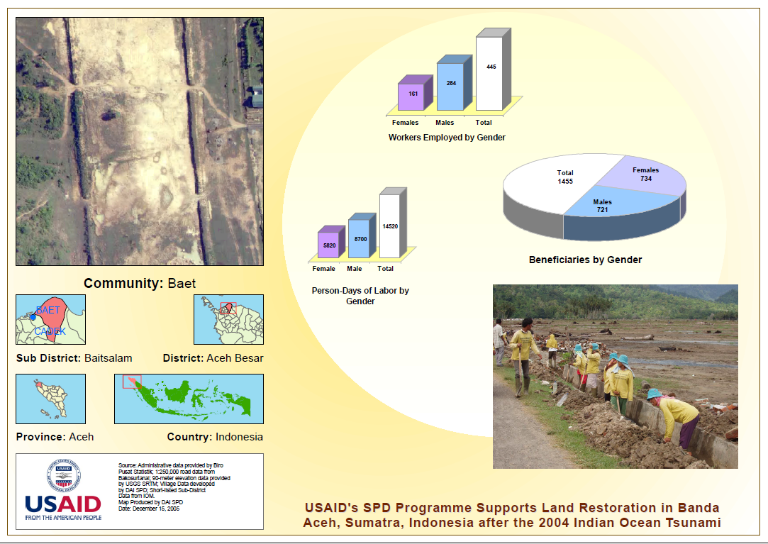
SUPPORT FOR PEACEFUL DEMOCRATIZATION (SPD) INDONESIA. In 2005 many
Indonesian communities in Sumatra were transitional from disaster and conflict to democratic governance. SPD
supported the transition with grants and capacity building to Civil Society Organizations (CSOs). Project
implementation and monitoring components require the collection of a large amount of information which must be
analyzed and reported in a manner that is logically and qualitatively consistent with DAI's and USAID's internal
controls and Management Information Systems (MIS)
|
| Location & Dates: |
JAKARTA, INDONESIA (02/2006 TO 10/2007) |
| Position: |
SENIOR GIS ADVISOR: Responsible for oversight in the design, quality assurance and production of
databases, maps, reports and statistical analysis associated with USAID community grants; served as
trainer/mentor for the GIS and Data Management Unit in the management and quality control of Outputs Quality
Assurance db, Village Profiles database, Community Action Plans database, and a number of databases from
subcontractors. Overall strengthening of community level governance to adapt to post-tsunami and post-conflict
environments through practical, hands-on change-management techniques. Examples include, strengthening the
capacity of CSOs in project formulation/justification using IT and relevant data management techniques in a
participatory planning process.
|
| Employer: |
DEVELOPMENT ALTERNATIVES INC. |
| 9. PROJECT: |
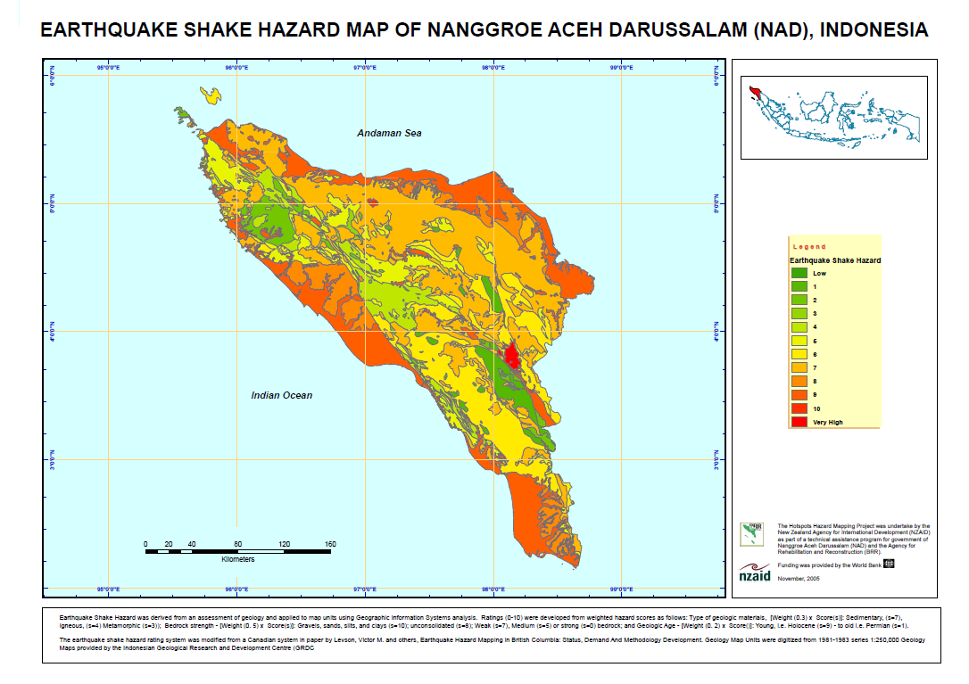
HOTSPOTS HAZARDS MAPPING FOR TSUNAMI AFFECTED AREAS IN BANDA ACEH,
INDONESIA. After the 2004 earthquake which triggered the Indian Ocean tsunami, the World Bank and New
Zealand Aid assisted with a "Build Back Better" program in Indonesia. A team of international experts were
recruited with expertise in earthquake-resilient engineering and Hotspots Mapping of disaster-prone areas. The
Hotspots Mapping project developed provincial scale multiple hazard maps as a integrated framework for more
detailed spatial planning and hazard mapping levels at the district, sub district and community levels
|
| Location & Dates: |
BANDA ACEH, INDONESIA (09/2005 TO 11/2005) |
| Position: |
SENIOR ADVISOR: to World Bank Badan Rekonstruksi dan Rehabilitasi (BRR). Sourced datasets from
national agencies such as BAKOSURTANAL, PUSLIKTANAK, GRDC, BPN, BMG and VSI; developed a Hazard Hotspots Map for
BRR to show how the interaction of geology, soils, topography, hydrology, and coastal bathymetry created high
risks for vulnerable settlements & infrastructure; modeled environmental impacts of unmitigated disaster - such
as tsunami flooding and run-up models in coastal areas and upland areas; developed Mercalli Scale maps (modeling
shake intensity); identified areas with high vulnerability to earth quake and tsunamis including watersheds
prone to tsunami flooding and inundation, soil liquefaction, landslides and erosion; advised on disaster
mitigation measures such as awareness programs and preparedness; presented stakeholders with the results as maps
and reports.
|
| Employer: |
NZAID DIVISION IN PARTNERSHIP WITH THE WORLD BANK |
| 10. PROJECT: |
DEVELOPMENT OF A UNHCR STRATEGY FOR OPERATIONAL DATABASE MANAGEMENT,
ANALYSIS AND REPORTING. UNHCR adopted a Standards and Indicators Reporting (SIR) methodology which informed
a Results-Based Management System. Weaknesses in data gathering and analysis processes at the field level
hampered the compilation of reliable demographic, operational analysis needed for the preparation of
assessments, Country Operation Plans, interagency coordination, resource mobilization and donor relations. The
study identified and documented weakness and proposed a mitigation strategy
|
| Location & Dates: |
GENEVA, SWITZERLAND AND FREETOWN, SIERRA LEONE (03/2005 TO 05/2005) |
| Position: |
SENIOR OPERATIONAL DATA MANAGEMENT CONSULTANT: Engaged Senior Managers in consultative study
methodology which included representatives from UNHCR headquarters in Geneva to the refugee-camp level, using
Sierra Leone as a case study; identified and documented existing weakness in UNHCR's Current Data Management
System; utilized participatory techniques, primarily focus groups and individual interviews as well as to gather
specific proposals and strategies to address these gaps.
|
| Employer: |
UNITED NATIONS HIGH COMMISSION FOR REFUGEES (UNHCR) |
| 11. PROJECT: |
DEPHA, DATA EXCHANGE PLATFORM FOR THE HORN OF AFRICA (HOA). An
interagency project with a mission to improve the management, access and exchange of geomatics products and
services in seven east African countries namely, Djibouti, Eritrea, Ethiopia Kenya, Somalia, Sudan, and; Uganda
|
| Location & Dates: |
NAIROBI, KENYA (06/2003 - 03/2004) |
| Position: |
PROJECT MANAGER: Responsible for the direction, management, and development of DEPHA resources and
staff. Key tasks include; mobilization and coordination of stakeholder/donor resources and needs; formation of
strategic partnerships to support emergency, humanitarian and development interventions in the HoA; development
of data standards, information sharing protocols and improved exchange technology. An ongoing and parallel focus
is to identify and act upon meaningful ways and means to use GIS, MIS and other geospatial technologies to
improve local governance, through joint ventures, participatory learning activities and assistance with the
selection of appropriate technology.
|
| Employer: |
UNITED NATIONS DEVELOPMENT PROGRAM (UNDP) |
| 12 PROJECT: |
BOSNIA AND HERZEGOVINA LANDMINE IMPACT SURVEY (LIS). A LIS is a standard
methodology implemented worldwide to identify and rank the severity of landmine impact on communities. Survey
results are used to guide Land Mine Action policy and to prioritize programming. A LIS is an International
Standards Organization (ISO) certified process that is recognized under the International Campaign to Ban
Landmines (ICBL)
|
| Location & Dates: |
SARAJEVO, BOSNIA AND HERZEGOVINA (11/2002 TO 06/2003) |
| Position: |
GIS CONSULTANT: Responsible for implementation of the spatial analysis component of the LIS. Advice
and direction was provide to the LIS Survey Team on sampling strategy, creation of a digital gazetteer, training
in field data collection methods such as GPS, data recording and data-chain management, development of
standardized maps and data.
|
| Employer: |
HANDICAP INTERNATIONAL, FRANCE AND SURVEY ACTION CENTER, WASHINGTON |
| 13. PROJECT: |
COORDINATION OF HUMANITARIAN ASSISTANCE IN FYROM. The United Nations
Office for the Coordination of Humanitarian Affairs (OCHA) was responsible for maintaining a coordination
database of humanitarian activities in the country. The Database was meant to give a rapid picture of "Who does
What Where", a standard approach of OCHA
|
| Location & Dates: |
THE FORMER YUGOSLAVIA REPUBLIC OF MACEDONIA (FYROM) (06/2002 TO 08/2002) |
| Position: |
GIS CONSULTANT: A short-term input to assist OCHA with setting up the database and linking the data
to a GIS System so that the activities could be presented spatially
|
| Employer: |
THE UNITED NATIONS OFFICE OF COORDINATION OF HUMANITARIAN AFFAIRS (OCHA) |
| 14. PROJECT: |
INFORMATION MANAGEMENT FOR LAND RESOURCES PLANNING AND MANAGEMENT. The
project supported the Government of Libya (GOI) with resilient strategies for rangeland management in areas
bordering the Southern Sahara and the northern Mediterranean coastline. Implementation involved coordination of
6 major agencies responsible for the management of soils, water and land information management, under the
direction of a Chief technical Advisor, a Project Steering Committee and National Work Groups. A Land Resources
Information Management System(LRMIS) was designed, built and deployed in the Agriculture Ministry to address
climate change vulnerabilities such as shallow soils, a falling water table and the threat of saline water
intrusion
|
| Location & Dates: |
CAIRO, EGYPT, TRIPOLI, LIBYA AND ROME, ITALY (03/2001 TO 03/2002) |
| Position: |
CHIEF TECHNICAL ADVISOR/INFORMATION SPECIALIST: Supervised the LRMIS team and built capacity for
Business Applications in Land Evaluation, Planning and Management at National and Regional Levels; updated the
LRMIS with GIS and Remote Sensing data; managed the signing of Letters of Agreement (US$200,000) between 2 GOL
agencies and FAO for information and data services; formed 6 national work groups and developed TOR to
coordinate national level input to LRMIS standards; scheduled 3 technical missions for international
consultancies for LRMIS inputs; lead National Work Groups in the acquisition and quality assurance of land
resource data, including soils, agriculture, agrometerology, water resources, land use/land tenure and
acquisition of geodetic data controls points; introduced, and set up a Training Program in National Spatial Data
Infrastructure (NSDI), workshops, thematic data warehouses and successfully introduced and installed an
Integrated MIS using UN-FAO approved methodology; maintained an excellent working relationship with project
personnel in Cairo, Tripoli and Rome, Italy.
|
| Employer: |
FOOD AND AGRICULTURE ORGANIZATION (FAO) OF THE UNITED NATIONS |
| 15. PROJECT: |
TECHNICAL ASSESSMENT AND PROJECT DOCUMENT PREPARATION FOR LOCAL SETTLEMENT
AND INTEGRATION OF INTERNALLY DISPLACED PERSONS (IDPS) IN INDONESIA. Technical Assessment and Project
Document Preparation for Local Settlement and Integration of Internally Displaced Persons (IDPs) in the province
of Nusa Tenggara Timur (NTT) in Indonesia
|
| Location & Dates: |
WEST TIMOR, INDONESIA (03/2000 TO 05/2000) |
| Position: |
LAND USE AND RURAL DEVELOPMENT ADVISOR: Conducted surveys in 25 villages throughout NTT to access
willingness to accept refugees and/or Internally Displaced Persons (IDPs); Determined, in consultation with
local leaders, that the carrying capacity of the Land Utilization Types (LUTs) in the villages (which were
largely rain-fed subsistence agriculture enterprises) could in general only support an additional 25% of its
current capacity (populations of humans and/or livestock) unless substantive external inputs were made
available; Reported the above results to UNHCR in writing and verbally through weekly correspondence.
|
| Employer: |
UNITED NATIONS OFFICE FOR PROJECT SERVICES (UNOPS) KUALA LUMPUR, MALAYSIA |
| 16. PROJECT: |
KUTAI DROUGHT MITIGATION INTERVENTION PROJECT, (KDMIP). KDMIP provided short
and long-term mitigation to 20,000 families prone to climatic and human-induced forest disturbances and
degradation in remote areas of the Mahakam watershed basin, accessible only by boat. A Food For Work (FFW)
program targeted the extremely vulnerable while adaptive Agro-Forestry Practices were encouraged for the longer
term. A challenge was to maintain gender balance and sustainability within an emergency context
|
| Location & Dates: |
SAMARINDA, KALIMANTAN, INDONESIA (09/1998 TO 03/1999) |
| Position: |
PROJECT COORDINATOR: Implemented over 200 community projects in agriculture, agro-forestry,
fisheries, infrastructure and small enterprise; developed projects aimed at climate change resilience and
conflict resolution for communities living in impoverished Forestry/Agricultural fringe areas; developed
efficient methods of monitoring and evaluation project progress with participation from the local community.
|
| Employer: |
CARE CANADA, OTTAWA, ONTARIO, CANADA |
| 17. PROJECT: |
LAND RESOURCE EVALUATION AND PLANNING PROJECT (LREP II/D). The TA
Strengthened land use mapping capability in 18 Provincial Planning Agencies (BAPPEDA) by improved spatial
planning infrastructure and the introduction of "rule-base" planning methodology using Geographical Information
Systems (GIS) technology. An ArcInfo based development planning decision support system was designed for 5
provinces in Indonesia which incorporated both National and Provincial Planning laws.
|
| Location & Dates: |
5 PROVINCES (BALI, EAST JAVA, NTT, NTB AND EAST TIMOR) IN EASTERN INDONESIA (04/1997 TO 06/1998)
|
| Position: |
REGIONAL TEAM LEADER/SENIOR PHYSICAL PLANNER: Implemented LREP II/D in Eastern Indonesia;
successfully developed and demonstrated 20 development models for agriculture, agro-forestry aquaculture,
forestry, mining and tourism sectors. This required the collection and analysis of site assessments data from
over 25 national sources; formulation of methodology, guidelines and criteria including USDA soil mechanical
criteria for engineering design, natural hazards (volcanic, landslides, flooding, soil erosion), environmental
contamination parameters from agriculture, municipal and industrial, waste management and sources. Consulted
with stakeholders to test the GIS-based development planning models in high priority planning areas and ensured
that development plans complied with climatic, environmental, physiographic and cultural criteria. Built
capacity of GOI planners in technical, logistical and planning functions. LREP is currently referenced in the
Indonesia Climate Change Sectoral Roadmap 2009 and National Action Plan Addressing Climate Change, 2007.
|
| Employer: |
ULG CONSULTANTS LTD, WARWICK, ENGLAND |
| 18. PROJECT: |
GIS DATA CONSULTANCY SERVICES TO GOVERNMENT & INDUSTRY. FREELANCE CONSULTANT
AND OWNER OF MULTIMAP SERVICES. This was a home-based GIS Consultancy offering short-term data migration and
integrations services mainly to Canadian clients
|
| Location & Dates: |
BROOKS, ALBERTA, AND ST. JOHN'S, NEWFOUNDLAND, CANADA (02/1996 TO 04/1997) |
| Position: |
GIS MAPPING CONSULTANT: This work by nature was transitional from government civil services to
consulting services and included: Preparation of proposals, Expressions of Interests (EOI) for business
development; Oversight (as owner/operator) of the data conversion, processing, and integrations services;
|
| Employer: |
FREELANCE CONSULTANT AND OWNER OF MULTIMAP SERVICES, A PROVIDER OF QUALITY SPATIAL AND METADATA FOR
GIS & CAD CLIENTS
|
| 19. PROJECT: |
SOIL SURVEY, TECHNOLOGY TRANSFER, LAND USE PLANNING, GIS APPLICATIONS. The
Soil and Land Management Unit, Department of Forestry, Lands and Agriculture, NF Canada, in the 1970s, with
assistance from the Government of Canada decided to introduce an On-Farm Soil and Land Improvement Service to
local farms to better equip them to adopt sustainable soil conservation and land planning practices. The
program, known as the On Farm Mapping Program (OFMP), essentially focused on issues facing the farming
community: Land Management and Planning, Soil Conservation and Productivity and Soil Drainage
|
| Location & Dates: |
ST. JOHN'S, NEWFOUNDLAND, CANADA (04/1990 TO 03/1996) |
| Position: |
LAND MANAGEMENT SPECIALIST: Prepared detailed (1:3000) Land Use individual farms; Prepared detailed
(1:3000) Soil maps with specific and very Land Suitability Ratings which were supported by Pedalogical and
Agronomic Fertility Laboratory analysis; Introduced the concept of a Soil Management Unit as opposed to the
common term "soil polygon" to better reflect the actual farming practices and to better communicated results and
recommendations; Advised on numerous small-scale agriculture enterprises including Mushroom cultivation; land
valuation for farm resale; soil drainage; Soil Fertility; Represented the SML on the Departmental User Needs
Committee and offered advice on HR and training requirements especially in GIS/RS and the management land
related information.
|
| Employer: |
SOIL AND LAND MANAGEMENT DIVISION, DEPT. OF FISHERIES, FOOD & AGRICULTURE |
| 20 . PROJECT: |
SCREENING FEASIBILITY STUDIES FOR DETAILED ENGINEERING FOR
TRANSMIGRATION SETTLEMENT DEVELOPMENT. Feasibility studies and detail engineering for transmigration under
the Regional Physical Planning Programme for Transmigration (RePPProT) settlement development. The TA mapped and
assessed soils, landform, hydrology, forestry and other factors affecting human settlement capacity and
suitability. Geographically, the survey area stretched from the Oriomo-Fly Plain in the south to the Fly-Digul
Shelf in the upper reaches of the Digul River Watershed adjacent to the Papua New Guinea. Phase I was based on
satellite and air photo interpretation, but Phase II (1:50,000) and Phase III (1:20,000) involved intensive
ground truth. As the area had no roads, access was via a 1-2 day boat trip up the Digul river, or where
possible, via helicopter. This was a very challenging and dangerous mission into previously unexplored tribal
areas with little or no contact with the outside world. Technical challenges included a lack of basic mapping
and geodetic references and initially no air photos. Additional challenges included in excess of 6 meters of
annual rainfall, very steep, dissected topography, a high frequency of malaria and tuberculosis
|
| Location & Dates: |
MULTIPLE LOCATIONS IN EASTERN INDONESIA, INCLUDING MERAUKE, SORONG, BIAK (FORMER IRIAN JAYA), PAPUA,
AND AMBON, SERAM AND TERNATE IN THE MALUKU ISLANDS (04/1984 TO 09/1989)
|
| Position: |
Multiple Positions: Despite the challenges hardships and hazardous conditions referred to above, the
consultant remains humbled and fortunate to have endured these conditions for over 5 years. At the same time he
enjoyed good health, amicable relations with his co-workers, the local people and was promoted to positions of
increasing responsibility. Having been selected to decommission Lavalin's field and office operations he was the
last international consultant to depart the project. Key posts, covering a period of over 5 years (from 03/1984
to 07/1989) are described below.
|
| Location & Dates: |
MULTIPLE LOCATIONS IN EASTERN INDONESIA, INCLUDING MERAUKE, SORONG, BIAK (FORMER IRIAN JAYA), PAPUA,
AND AMBON, SERAM AND TERNATE IN THE MALUKU ISLANDS (04/1988 TO 09/1989)
|
| Position: |
SITE RECONNAISSANCE STUDY LEADER: Following technical feasibility studies under
the Trans V programme, the World Bank Funded reconnaissance missions and rapid appraisals to determine
remediation actions in selected agricultural villages which were cited as failed or failing Transmigration sites
in Eastern Indonesia. Travelled to about a dozen subsistence communities in eastern Indonesia to provided
oversight for site assessments and community surveys for infrastructure improvement projects in isolated
subsistence agricultural communities; capacity building, including training of 150 Indonesian counterparts in
RePPProT methodologies. Evaluated and assessed of urgent remediation and development needs; Developed a project
formulation report for immediate action based on the reconnaissance mission.
|
| Location & Dates: |
MERAUKE, (FORMER IRIAN JAYA), PAPUA, INDONESIA (01/1987 TO 03/1988) |
| Position: |
PHASE II TEAM LEADER: (Alternated as PROJECT MANAGER, PROJECT ADMINISTRATOR for
five months): Prepared progress reports to the World Bank's Regional and Central Advisory Groups; Coordinated
the technical inputs of a team of 15 International and 150 Indonesian consultants including Foresters, Soil
Scientists, and Land Use Planners; supervised external contractors and coordinated project outputs for the World
Bank Regional Advisory Group review process. Delivered 10 reports containing highly technical and comprehensive
land resource and planning information such as: Community Spatial Development plans; Assessment of 25 yr project
economic feasibility; Estimates of Commercial Timber; Soil Suitability Ratings for Upland/Lowland Crops;
Detailed infrastructure plans including road alignment and location of public facilities.
|
| Location & Dates:
|
MERAUKE, (FORMER IRIAN JAYA), PAPUA, INDONESIA (07/1986 TO 11/1986) |
| Position: |
SPATIAL PLANNING TECHNICAL ADVISOR: Technical Assistance to complete a
full-scale Transmigration Development Settlement Study. This work was essentially a follow-up from the previous
work (see below) but the focus was on capacity building. The consultant was selected from a Team of 18
consultants by Lavalin International Inc to supervise the work of an Indonesian Consultant to undertake a full
scale Settlement Development Study on their own, using the methods and procedures developed in earlier
feasibility studies. Principle Responsibilities/Achievements of the Consultant included:
Supervised all aspects of the Settlement Development Study; Liaised with the client (GOI) and the Contractor in
Canada; Led the team to a successful Project completion and client approval.
|
| Location & Dates: |
MERAUKE, (FORMER IRIAN JAYA), PAPUA, INDONESIA (03/1984 TO 03/1986) |
| Position: |
TECHNICAL ADVISOR/SOIL SCIENTIST: The consultant completed over 10 soil surveys
and land evaluation assessments under these conditions, complete with soil chemical and physical analysis as
well as meteorological data which formed part of a technical feasibility analyses which also accessed forestry,
hydrology and infrastructure; Supervised the preparation of reconnaissance and semi-detailed soil surveys in the
remote humid tropical rain forests of Papua, Indonesia; Evaluated the soil survey results using computerized
models based upon the FAO framework for Land Evaluation; Advised , on the soil and land suitability factors for
a range of tropical crops and FAO Land Utilization Type (LUTs); Prepared or assisted with the preparation of
over 35 Transmigration Development Settlement Feasibility Studies.
|
| Employer: |
LAVALIN INTERNATIONAL INC., CONSULTING ENGINEERS, MONTREAL, QUEBEC. |
| 21. PROJECT: |
KINGS COUNTY LAND PLANNING PILOT PROJECT (KC-LPPP). A joint Project of
Agriculture Canada and the Government of Nova Scotia KC-LPPP updated agricultural-forestry-industrial zones and
pioneered the first use of digital mapping in eastern Canada in Kings County Planning Authority, Kentville, Nova
Scotia. This was before the advent of ESRI and other Off-the-Shelf Geographic Information Systems (GIS)
technology
|
| Location & Dates: |
TRURO, AND KENTVILLE, NOVA SCOTIA, CANADA (06/1980 TO 03/1984) |
| Position: |
PROJECT MANAGER: Managed a team of 6 soil surveyors, cartographers, and students assistants;
responsible for the project budget, all administrative tasks and liaison with the Donor, Federal Technical
Project Officers and the client; prepared GIS-Based Canada Land Inventory (CLI) capability classification in
Nova Scotia's Minas Basin; developed a system for evaluating the suitability of soils for agriculture,
irrigation and agricultural waste disposal; field tested National Soil and Water Conservation methods prepared
by national working groups; and; prepared 2 Soil Survey and Land Planning reports which were published and
incorporated in Canada's Soil Information System (CANSIS); successfully expanded the pilot project to other Nova
Scotia Counties and secured a four-fold increase in funding.
|
| Employer: |
NOVA SCOTIA DEPARTMENT OF AGRICULTURE AND MARKETING, TRURO, NOVA SCOTIA |
| |